Regional Geology
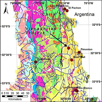
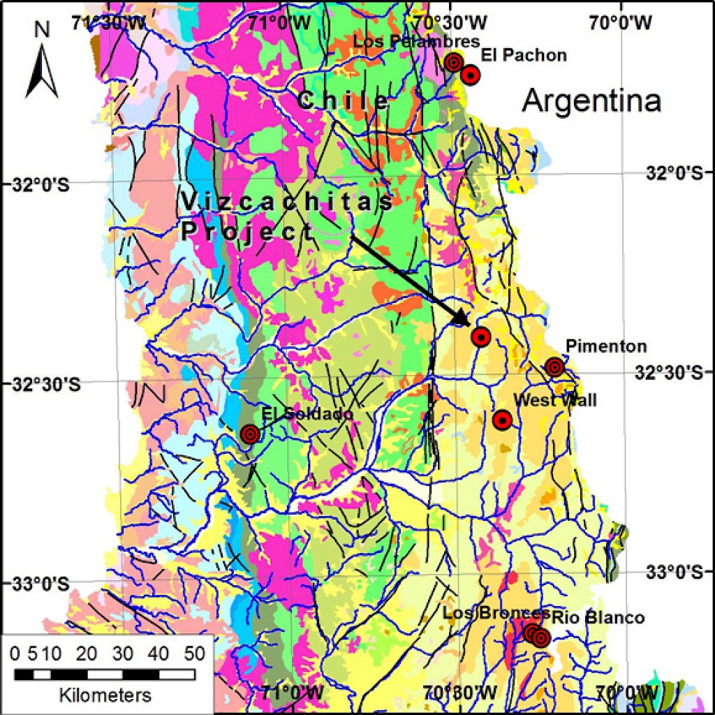
The dominant geological feature of this region is the north-south trending Neogene (23 - 2.5 million years ago (Ma)) metallogenic belt that extends along the slopes of the Andean Cordillera in Chile and Argentina. In central Chile, this metallogenic belt includes world class Cu-Mo porphyries, such as: Los Pelambres-El Pachón located 75km north of the Vizcachitas deposit, Río Blanco-Los Bronces located 80 km to south of Vizcachitas and El Teniente located 180 km to the south.
In central Chile, the Neogene metallogenic belt coincides with the position of Miocene volcanic centers and associated flat-lying volcanic rocks, sills, and dikes. The Miocene volcanic sequence, with an average thickness of 2,500 m, comprises andesite, basalt (lavas and sills), dacite, and intercalations of rhyolitic tuff, which constitute a north-south belt approximately 20 km wide (Farellones Formation; Thiele, 1980; Rivano et al., 1990). Eruption of these volcanic rocks occurred at a number of volcanic centers, possibly localized by intersections of regional structures. These volcanic rocks overlie folded Oligocene (34 – 23 Ma) to early Miocene andesitic volcanic and continental sedimentary rocks (Abanico and Coya-Machalí Formations in a non-conforming manner; Thiele, 1980; Charrier et al., 2002).
The Neogene porphyry Cu-Mo deposits occur within hydrothermal alteration zones related to multiphase porphyritic stocks with compositions ranging from quartz diorite to granodiorite. These intrusions and their country rocks host dense networks of sulphide-bearing veins and associated hydrothermal breccia complexes. The country rocks are: late Miocene basaltic and andesitic volcanic rocks, diabase sills, and gabbro at El Teniente; Miocene andesite and a middle Miocene granodioritic batholith at Río Blanco-Los Bronces (San Francisco batholith; Serrano et al., 1996); and folded Lower Cretaceous (145 - 100 Ma) volcanic and sedimentary rocks at Los Pelambres (Atkinson et al., 1996).
Dates obtained by General Minerals Corporation on biotite from four intrusive rocks yielded ages between 10.4 and 12 ± 0.3 Ma for the Vizcachitas project (Osterman, 1997).
District Geology
The oldest rocks within the district correspond to a sequence of andesitic to basaltic-andesite volcanic flows and volcanic flow breccias that crop out along the lower half-slope on the western side of the Rio Rocín Valley. Volcanic “bedding” in this lower andesite sequence is predominantly striking N-S to NE-SW and dipping towards the west. The lower andesite sequence is commonly altered to chlorite-epidote without pyrite, an assemblage that is tentatively interpreted to represent a regional characteristic of this unit, perhaps related to very low-grade metamorphism and not true propylitic alteration. True propylitic altered andesite are recognized locally where disseminated or veinlet controlled-pyrite is observed. The lower andesite sequence is overlain by a well-bedded sequence of interlayered conglomerates (reddish coloured), andesite flows and andesite flow breccias that crop out over the higher-half slope to the west of the Rio Rocín valley. They correspond to the conspicuous volcanic beds and strata that can be recognized from the distance.
From a regional stratigraphic perspective the lithologies described above have been mapped/interpreted in different ways over the years. SERNAGEOMIN initially mapped the lower sequence (predominantly andesite and basaltic-andesite flows) as part of the Cretaceous Los Pelambres Formation (Hoja Geológica Quillota y Portillo, 1:250.000, 1993) and the higher sequence (including the well-bedded conglomerates and volcanic breccias) as Farellones Formation (early to mid-Miocene in age). However, a more recent PhD Thesis from Universidad de Chile (Pamela Paz Jara Muñoz, Tesis Doctoral, 2013) proposed that the lower sequence is actually part of the late-Eocene/early Miocene Abanico Formation. It is in understood that this re-interpretation was derived from regional mapping supported by U/Pb zircon dating. The observations of basaltic andesite in the lower sequence is in agreement with the predominance of maphic volcanic rocks described for the Abanico Formation (Fuentes et. al., 2002).
A series of holocrystalline equigranular to inequigranular fine to medium-grained intrusions ranging in composition from granodiorite to quartz-diorite and also including diorite out crop to the west, east and to the north of the Vizcachitas deposit. These intrusions range in size from a few hundred meters up to >2 kms across. The largest is represented by a predominantly granodioritic/quartz dioritic intrusion that surrounds the Vizcachitas deposit on the west, on the east and to the north and is tentatively interpreted to represent a pre-mineral, precursor pluton. The most intensely altered and veined intrusive exposed north of the Vizcachitas deposit corresponds to the Las Cienaguitas area. This intrusive is responsible for the development of locally intense pyrite (+/- tourmaline) veining and silicification in the volcanic host-rock.
Vizcachitas Geology
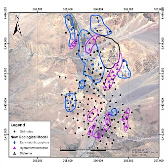
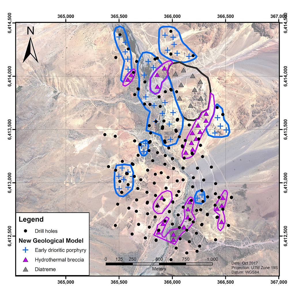
As part of the project review carried out in 2015, the Los Andes Copper geologist relogged all of the 146 diamond drill holes that have been drilled on the property since the 1990’s.
The relogging was carried out under the leadership of Gonzalo Saldias, a well recognized and experienced Chilean porphyry geologist. This logging identified the importance of the early diorite porphyry and the later hydrothermal breccias in controlling the higher grade mineralisation. The previous geological model had grouped together all the dioritic rocks and the various breccias. The new model has differentiated these units.
The host rocks at Vizcachitas are Oligocene-Miocene (33-5.3 Ma) andesite of the Abanico Formation. The earliest intrusive phase at Vizcachitas was a sequence of diorite units ranging from fine grained through to porphyritic phases. The early diorite porphyry is generally deeper and on the eastern side of the project. In some drill holes it was only intersected in the last tens of meters of the drill holes.
The extent of hydrothermal breccias had not been fully recognised in the previous logging. The current mapping shows that there are two areas: one to the south east and the other in the central core of the project. The central core hydrothermal breccia has been cut by a later diatreme breccia.
The relogging showed that these higher grade geological units extend over a distance of 1,400 metres north-south and 700 metres east-west. The mapping shows that these breccias have grades increasing with depth and demonstrates the potential for higher grades below the current drilling.